Imagine you are lost in a new city, trying to find your friend’s house. You open your phone, and a blue dot shows your exact location while the map guides you step by step.
That magic happens because of GIS and GPS working together. The difference between GIS and GPS is often confusing, but both play a huge role in modern navigation.
The difference between GIS and GPS helps us understand how maps are created and how location is tracked.
The difference between GIS and GPS is also important in education, transportation, and disaster management.
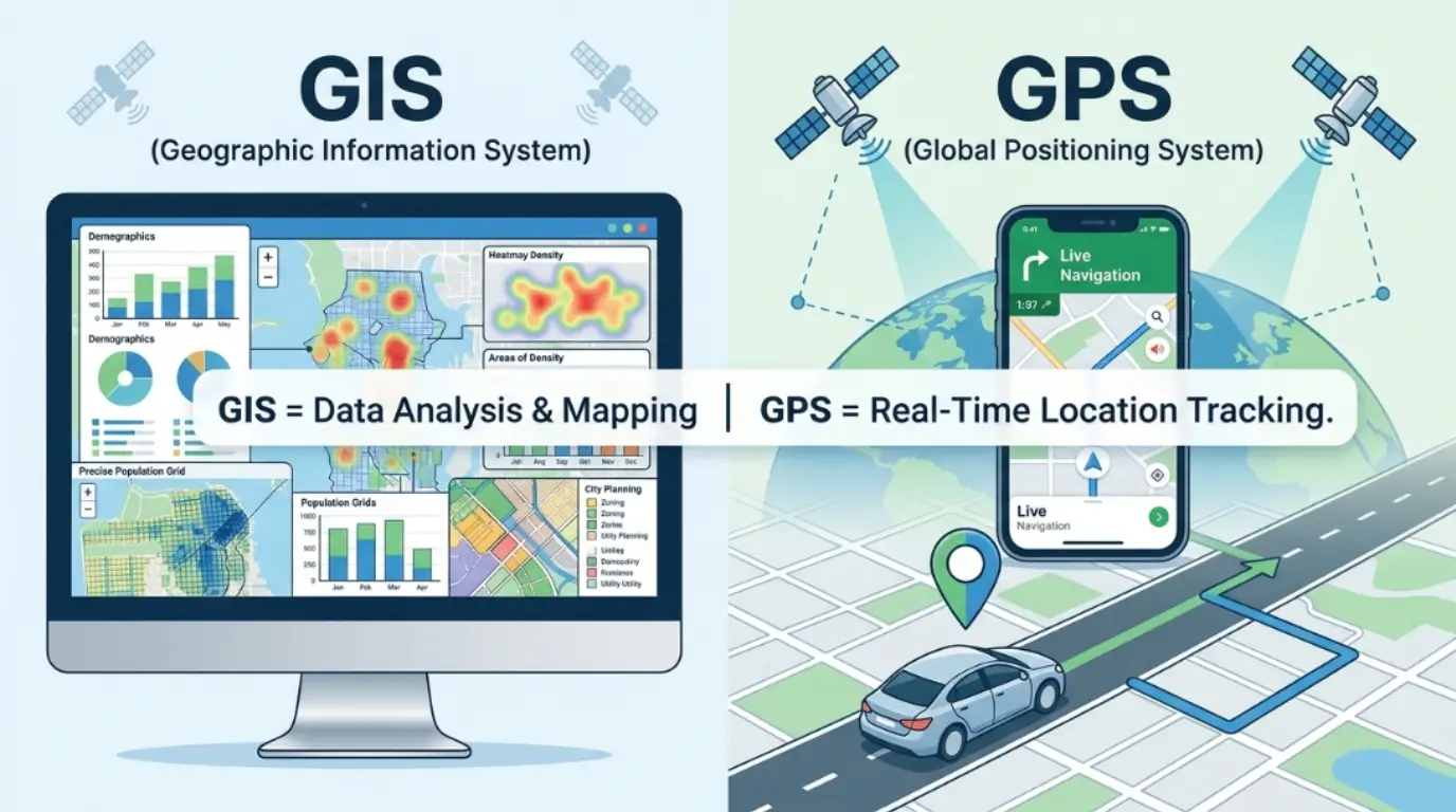
In simple words, GIS is the brain that analyzes data, while GPS is the eyes that finds location. Let’s explore them deeply.
Pronunciation
- GIS: /ˌdʒiː.aɪˈɛs/ (US & UK)
- GPS: /ˌdʒiː.piːˈɛs/ (US & UK)
Now let’s connect this understanding to their core differences.
Key Difference Between GIS and GPS
GIS (Geographic Information System) is a computer-based system used to capture, store, analyze, and visualize geographic data. GPS (Global Positioning System) is a satellite-based navigation system used to find exact location on Earth.
Simply put:
- GIS = Data + Mapping + Analysis
- GPS = Location Tracking System
Why Understanding the Difference Between GIS and GPS Is Important
Understanding the difference between GIS and GPS is essential for students, engineers, and researchers. These technologies are widely used in urban planning, agriculture, disaster response, and transportation systems.
The difference between GIS and GPS helps professionals choose the right tool for the right job. For example, GPS helps delivery riders find addresses quickly, while GIS helps governments plan smart cities.
Without knowing the difference between GIS and GPS, people may misunderstand how mapping systems work. In today’s digital world, both systems shape how we interact with geography, making this knowledge highly valuable for education and real-life applications.
Difference Between GIS and GPS (10 Key Points)
1. Definition
- GIS: A system for analyzing spatial data.
Example: City planning maps. - GPS: A system for location tracking using satellites.
Example: Google Maps navigation.
2. Function
- GIS: Works with data analysis and visualization.
Example: Flood risk mapping. - GPS: Provides real-time location.
Example: Taxi tracking apps.
3. Components
- GIS: Hardware, software, and data layers.
Example: ArcGIS software. - GPS: Satellites, receivers, and signals.
Example: Smartphone GPS chip.
4. Purpose
- GIS: Used for decision-making.
Example: Urban development planning. - GPS: Used for navigation.
Example: Driving directions.
5. Data Type
- GIS: Uses spatial and non-spatial data.
Example: Population + map data. - GPS: Uses location coordinates.
Example: Latitude and longitude.
6. Output
- GIS: Thematic maps and reports.
Example: Climate distribution maps. - GPS: Coordinates and routes.
Example: Route to nearest hospital.
7. Accuracy Role
- GIS: Depends on data quality.
Example: Environmental studies. - GPS: Depends on satellite signal.
Example: Real-time positioning.
8. Application Area
- GIS: Research, planning, environment.
Example: Wildlife tracking systems. - GPS: Transportation and travel.
Example: Car navigation systems.
9. Technology Type
- GIS: Software-based system.
Example: QGIS tools. - GPS: Satellite-based system.
Example: Garmin devices.
10. Dependency
- GIS: Can use GPS data for analysis.
Example: Mapping traffic patterns. - GPS: Works independently for location.
Example: Standalone GPS devices.
Nature and Behavior of GIS and GPS
GIS behaves like an intelligent analyst. It collects data, organizes it, and creates meaningful maps for decision-making. It does not just show where things are; it explains why they are there.
GPS behaves like a real-time tracker. It constantly receives signals from satellites and updates your position. It does not analyze data; it only shows location. Together, they form a powerful combination where GPS provides raw location data and GIS transforms it into useful insights.
Why People Get Confused
People confuse GIS and GPS because both deal with maps and location. Mobile apps like Google Maps use both systems together. GPS gives your current position, while GIS builds the map interface and calculates routes. Since they work side by side, users often assume they are the same technology. However, their functions are completely different.
Table: Difference and Similarity Between GIS and GPS
| Feature | GIS | GPS |
| Type | Data analysis system | Satellite navigation system |
| Function | Mapping & analysis | Location tracking |
| Output | Maps & reports | Coordinates |
| Dependency | Uses GPS data | Works independently |
| Similarity | Both deal with geography | Both used in mapping |
Which Is Better in What Situation?
The difference between GIS and GPS clearly shows that neither is “better” in general. GIS is better when analysis and planning are required, such as urban development or environmental studies. GPS is better when real-time navigation is needed, like driving or delivery services. If you want to understand patterns, GIS is the right choice. If you want to reach a destination quickly, GPS is essential. In modern systems, both work together to give complete solutions. For example, logistics companies use GPS for tracking vehicles and GIS for route optimization, making operations more efficient and accurate.
Metaphors and Similes
- GIS is like a “brain” of geography that thinks and analyzes data.
- GPS is like “eyes in the sky” guiding your position.
- GIS works like a librarian organizing maps.
- GPS works like a compass pointing you home.
Connotative Meaning
- GIS: Positive (intelligent, analytical, planning tool)
- GPS: Positive (helpful, guiding, navigation tool)
Both are seen positively in modern society because they improve safety, travel, and decision-making.
Idioms or Proverbs (Related Concepts)
- “Know where you stand” → GPS helps you know your exact position.
- “Look at the bigger picture” → GIS provides overall spatial analysis.
GIS and GPS in Literature
- “The Geography of Thought” – Richard Nisbett (2003, Psychology/Geography concepts)
- “Maphead” – Ken Jennings (2011, Non-fiction geography exploration)
Movies Related to Mapping and Navigation Concepts
- The Martian (2015, USA) – survival navigation on Mars
- Interstellar (2014, USA) – space navigation and coordinates
Frequently Asked Questions (FAQs)
1. What is the main difference between GIS and GPS?
GIS analyzes data while GPS provides location tracking.
2. Can GIS work without GPS?
Yes, GIS can use other data sources besides GPS.
3. Is GPS part of GIS?
GPS can provide data used in GIS systems.
4. Where is GIS used?
Urban planning, environment, agriculture, and research.
5. Which is more important, GIS or GPS?
Both are important and often used together.
Conclusion
The difference between GIS and GPS shows that both technologies serve unique and important roles. GIS focuses on analyzing and visualizing geographic data, while GPS focuses on providing real-time location tracking.
Together, they create powerful systems used in transportation, disaster management, agriculture, and smart city planning. Understanding the difference between GIS and GPS helps students and professionals choose the right tool for the right purpose.
In today’s world, where location intelligence is crucial, both systems complement each other perfectly. Whether you are navigating a road or analyzing global patterns, GIS and GPS work hand in hand to make life easier, smarter, and more connected.